

Where to Visit around Chirk
|
Coal was mined at Halghton to the north-east of Chirk as early as 1622 and Sir Thomas Myddelton of Chirk Castle, who was a partner in the Ruabon furnace in 1631/2, set up the Pont y Blew Iron Forge on land near the Halghton coal pits in the early 1630's. A legal dispute which took place in the 1690's between the Myddeltons of Chirk Castle and the Trevors of Bryn Kynalt over the mining of coal shows the new importance of coal in the Chirk area, an importance that would grow through the 18th and 19th centuries and influence the development of Chirk town and the surrounding area. Black Park colliery and Pont-y-Blew Forge, were leased from Chirk Castle estate in the 1800's. The mine was developed until 1877 when a Lancashire company was formed to purchase it. The company flourished under a succession of general managers, who played an active role in developing the town through the provision of community recreation facilities and improved living conditions for the miners, notably Mr James Darlington. Black Park colliery closed in 1949. Bryn Kynalt colliery sunk in 1870 and worked until 1968 and nearby Chirk Bank Colliery, recorded as early as 1801 and closed in the 1880's also provided employment and business for the Town and its people. While coal mining and iron working was taking place in the 18th century, lines of communication were being developed to link the mines to the market places. A canal was built in the late 18th century with rails linking the coal pits of Halghton to the canal wharfe and the A5 road was improved by Telford to improve the coach route from London to Holyhead. Railway communications were introduced to Chirk in the late 1840's by Henry Robertson.
This highly decorative small building (left photo) was built in 1904 as a mausoleum for Mary Rosamund, daughter of the second Lord Trevor who died aged 5. The Norman style of this miniature building, clearly indicates the influence of Norman architecture, the arched entrance door showing examples of Norman Church architecture. Note particularly the semi-circular arch incorporating carved chevron moulding, typical of the Norman period, this also shows around the bull's eye window, above the doorway and in the arch of the side window. Castell y Waun, Norman Motte The circular mound is about 90 feet in diameter, is cone-shaped with a flat top and is a scheduled ancient monument. This is the site of the first castle of Chirk and is the motte of the motte and bailey castle built by the Normans when they occupied Chirk in the early 12th century. It is likely that a simple timber tower was built on the top of the mound and from this position the Norman sentries could view the crossing point or ford over the River Ceiriog to the south of the castle, thus effectively blocking the passage of armies from Shropshire to the valley of the Dee. This was the line of approach of Henry II in his campaign in the year 1164 against Owain Gwynedd when the King made desperate attempts to take the castle. The King's army was defeated by the Welsh at the battle of Crogen in the Ceiriog Valley which took place two miles to the west of Chirk.
'Pont' is the Welsh name for bridge, 'faen' from 'Maen' means stone. The literal translation is stone bridge. The single arched bridge is of late 18th century date, having a semi-circular arch, a flat stone string course and stone slab parapets. Chirk Bridge The Bridge was constructed in about 1798 by Thomas Telford as part of his improvements and diversion of the London to Holyhead coach road on this crossing point of the River Ceiriog and approach ascent to Chirk from Shrewsbury. Features of the construction are the single segmental arch, projecting keystone, rusticated voussoirs which are struck through to the soffit. A flat string course and pilasters, coped parapet and rectangular corner piers complete the design. The structure has later repairs and alterations, hence the date stone 1831 on the eastern parapet. The bridge was widened to its present form in the 1920's and is faced with the original masonry. The yellow sandstone ashlar of the construction gives a warm colour to this part of the riverside and one views through the bridge arch the white-washed 'Riverside' cottages on the river bank beyond the bridge. |
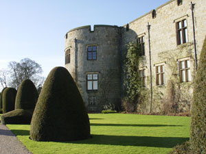 Situated
on the summit of a hill overlooking the border of England and Wales, Chirk
commanded a strategic location, as is evidenced by the Motte and
Situated
on the summit of a hill overlooking the border of England and Wales, Chirk
commanded a strategic location, as is evidenced by the Motte and
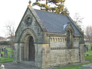 Mausoleum
of Mary Rosamund
Mausoleum
of Mary Rosamund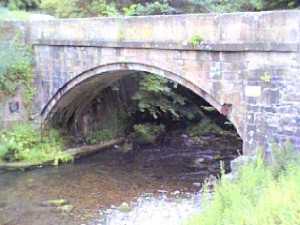 Pont-faen
(Right Photo)
Pont-faen
(Right Photo)
| Click on the town name below to visit other areas of Wales or Here for Map | ||||||
| Aberaeron | Aberdovey | Abergavenny | Aberystwyth | Amlwch | Bala | Barmouth |
| Beaumaris | Beddgelert | Betws-y-Coed | Brecon | Builth Wells | Caernarfon | Caldey Island |
| Cardiff | Cardigan | Carmarthen |  |
Chepstow | Chirk | Colwyn Bay |
| Conwy | Crickhowell | Denbigh | Fishguard | Flintshire | Harlech | |
| Haverfordwest | Holyhead | Llanberis | Llandrindod | Llandudno | Llangollen | |
| Machynlleth | Newport | Newtown | Porthcawl | Porthmadog | Pwllheli | Rhayader |
| Rhyl | Ruabon | Ruthin | Saundersfoot | St Asaph | St Davids | Swansea |
| Tenby | Welshpool | Wrexham | Travelazzi | Old Photos | Chester | Oswestry |
Copyright © 1998 - 2019