Snippets from History
|
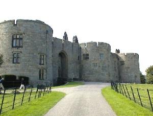
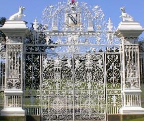
The area was sold for £5000 to Sir Thomas Middleton in 1595 and he and his successors have occupied the castle ever since. The fine castle is probably the most famous aspect of Chirk, having spectacular views looking into the town and the surrounding areas. This site is also believed to be in the position of an earlier building, Castell Crogen, although no physical remains have been found. The magnificent ornamental gates at the castle's entrance were built by the Davies brothers of Bersham in about 1718, although their current position is at least the third site they have occupied. They are known locally as "The Pretty Gates ". It is often assumed that the gates were originally painted "traditional black" but in fact they were only painted that colour during the 1939-1945 war. Running north to south across the castle grounds is Offa's Dyke, reputedly built by King Offa about 790AD. Although some parts of the dyke have been dismantled, or are inaccessible, visitors walking just a small section cannot fail to appreciate the vast undertaking that this must have been in its day, standing some 20 ft. high and running for 168 miles to clearly mark the boundary between Wales and England.
Next and also on the right, you will see St Mary's Church. In Welsh, it is Eglwys y Waun "The Church on the Moor". There is believed to have been a small wooden church standing on the site before the stone one was erected. The original part of the Church is Norman, built in the 12th century with the Tower and a single nave, with the second (north) nave added much later in the late 15th century. There have subsequently been numerous repairs and alterations to the building, some of which are clearly visible today. Within the building there are monuments to the Myddletons of Chirk Castle and the Trevor family from Brynkinallt Hall, besides other interesting plaques and objects. Coalmining has played a large part in the social history of Chirk, being active from the sixteenth to the twentieth century. In the seventeenth century ironworks were developed too. All mining and associated industry has now ceased. Some fine houses were built in Chirk for the coal managers, an example, Bryn Coed in Castle Road is an attractive and decorative building in the Restoration Revival style built in 1912 for the manager of Brynkinallt Colliery in Chirk Green. A narrow gauge tramway was built from Chirk in 1870 linking the canal to the quarries and mines at Glyn Ceiriog. Originally horse-drawn, the tramway was converted to steam in 1888, re-routed to link with the main line rails at Chirk Station and extended to Hendre dolerite (granite) quarry, making a total length of 8 miles. It carried slate, silica, chinastone and dolerite downstream, and returned with coal, flour and other commodities. Passenger facilities were also provided, though it took an hour to cover the 6 miles from Glyn Ceiriog to Chirk, and cost 8 old pence (3p). The line closed to passengers in 1933 and to all traffic 2 years later. The bed of the tramway is still visible in various places including just behind the Chester platform on Chirk Station. |
| Click on the town name below to visit other areas of Wales or Here for Map | ||||||
| Aberaeron | Aberdovey | Abergavenny | Aberystwyth | Amlwch | Bala | Barmouth |
| Beaumaris | Beddgelert | Betws-y-Coed | Brecon | Builth Wells | Caernarfon | Caldey Island |
| Cardiff | Cardigan | Carmarthen |  |
Chepstow | Chirk | Colwyn Bay |
| Conwy | Crickhowell | Denbigh | Fishguard | Flintshire | Harlech | |
| Haverfordwest | Holyhead | Llanberis | Llandrindod | Llandudno | Llangollen | |
| Machynlleth | Newport | Newtown | Porthcawl | Porthmadog | Pwllheli | Rhayader |
| Rhyl | Ruabon | Ruthin | Saundersfoot | St Asaph | St Davids | Swansea |
| Tenby | Welshpool | Wrexham | Photos | Old Photos | Chester | Oswestry |
Copyright © Mark Redfern 1998 -


 Chirk, whilst close to the
English border, and often occupied by the English, has always been in Wales.
The Ancient Britons were here and the Romans, who camped at Rhyn Park, must
have passed through. Later the Princedom of Powys held sway until the Norman
occupation of the 12th century. Llewelyn, Prince of Wales, was killed by the
forces of Edward 1st in 1282 and the land around Chirk was made the Marcher
Lordship of Chirklands. This was handed to Roger Mortimer, who built the
castle in 1310. Mortimer died a traitor in the tower of London.
 The town itself is
situated on the old turnpike road from London to Holyhead, which carried the
Irish Mail by stagecoach. This road, formerly the A5 and now the B 5020, was
the famous historic route created by Thomas Telford, the great 18th Century
engineer, who also designed Chirk Aqueduct. If you travel this route .from
the Oswestry direction, you will see on your left this magnificent yellow
sandstone structure, with ten symmetrical arches, spanning the Ceiriog
Valley and completed in 1801. It carries the Llangollen branch of the
Shropshire Union Canal. Standing behind it and overshadowing it to show 'the
superiority of rail over canal' is the Viaduct, built in 1848 to carry the
then newly constructed Chester to Shrewsbury railway line over the River
Ceiriog. Because of the hostility of Col. Robert Myddleton Biddulph of Chirk
Castle, it was built only at night! Continuing on that road to the top of
the hill, look to the right, amongst the trees, for the remains of a Motte
and Bailey castle of Norman origin.